| Types of Rock | | | Properties | | | Volcanoes | | | Articles |
A Map of the US 'Geological Basement' April 2015
The US Geological Survey (USGS) has recently completed a map of the so-called 'geological basement' of the USA, including Alaska.
The 'basement' is composed of crystalline rocks which lie above the Earth’s mantle but beneath all other rocks and sediments. These rocks are sometimes exposed at the surface, but more often they are buried under miles of other rock and sediment. Since the Earth's first crust developed some 3.6 billion years ago, about 80 layers of crust have been added to the basement. The US geological basement map is the first map to detail these segments from the most ancient to the most recent.
Before they become basement rock, the rocks of the crust are modified several times, and these transitions alter their composition. Ultimately, continental crust forms from pre-existing oceanic crust and overlying sediments.
By the time rocks from the continental crust become basement rocks they have been modified by a wide variety of plate tectonic events involving deformation, metamorphism, deposition, partial melting and magmatism.
For example, because the planet Earth has evolved during its 4.5 billion years of history, early rock deposits were formed when there was less oxygen in the atmosphere and the thin crust was hotter. These ancient domains are now more stable and less likely to be altered by modern processes that could cause metals to migrate.
By contrast, basement rocks that formed from the crust less than one billion years ago come from the more modern, thicker crust altered by - for example - plate tectonic processes. These rocks reflect a more mature planet with a thicker crust.
Because the basement rocks are often buried deep inside the Earth, they can only be mapped over large areas by the use of remote geophysical surveys. This most recent map was compiled using a variety of methods, including data from national-scale gravity and aeromagnetic surveys.
'Traditionally, scientists have assessed mineral resources using clues at, or near, the Earth's surface to determine what lies below,' said USGS scientist Karen Lund, who led the project. 'This map is based on the concept that the age and origins of basement rocks influenced the nature and location of mineral deposits. It offers a framework to examine mineral resources and other geologic aspects of the continent from its building blocks up,' said Lund.
By incorporating ancient to modern processes, this map offers a more complete and consistent portrait of the US geological basement than previous maps and can be used for future broad-scale mineral resource assessments and other geological studies.
Users can identify domains potentially containing specific metals or deposit types. The map also provides a template to correlate regional to national fault and earthquake patterns.
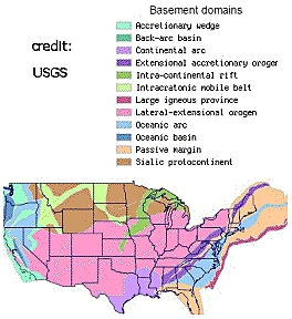
This map shows basement domains according to generalized original crust types.
Reference:
The basement domains are also available in list form at this location:
http://mrdata.usgs.gov/ds-898/domain-list.php
 |
© Biscuit Software 2016
All rights reserved