August Editorial
The age of the Tibetan Plateau
August Editorial
The age of the Tibetan Plateau
|
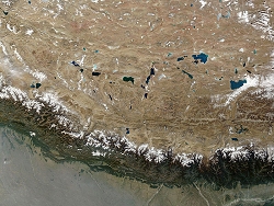
Tibet has the worlds highest and largest plateau. Its average elevation of over 4.5km (2.7 miles) above sea level has caused this region to be called the Roof of the World. The plateau is huge, an area of two-and-a-half million square kilometers. That's just short of a million square miles, or more than ten times the size of Great Britain, and approximately the size of Canadas two largest provinces, Ontario and Quebec, put together.
|
To the south the Tibetan Plateau is bordered by the Himalaya-Karakoram complex of mountains. These are impressively high as well, containing not only Mount Everest but all of the other thirteen peaks higher than eight thousand meters (five miles). There are also literally hundreds of other peaks over seven thousand meters high, all of which are higher than anywhere else on Earth. In fact the Tibetan Plateau may be the highest that such a large area of land has risen in all of the geologic history of our planet. |
|
|
It has not been easy for geologists to piece together the events which caused the region to rise so high, but every new study brings a new piece to fit into puzzle. But new some data only makes the picture even more confusing. For example, another thing that keeps the geologists busy is that the plateau is not only immensely high but also the continental crust beneath it is much thicker than in most other places on Earth. A crust 30 km (18.5 miles) thick is considered normal, but the Tibetan plateau lies on about 70 km of crust, and in places this gets to 100 km (62 miles) thick. The history of the plateau started, although indirectly, about 100 million years ago. That is when the super-continent Gondwanaland broke up, and the part that later became India began to drift towards Asia. It reached the main body of the continent 55 million years ago in a head-on collision. When two tectonic plates meet, one of them will subduct - that is, start to flow under the other. But when two continents meet, neither one can subduct because the continental rocks are too light. Instead there is a huge pile-up in the collision zone, and this what has happened, and is still happening, in Tibet. In 2008, following an eight-year collaborative study between US and Chinese researchers, a report was published in the Proceedings of the National Academy of Sciences (ref 1). The report was on a study of the age of the central part of the Plateau. The research used different techniques, including magnetostratigraphy. (This assesses the magnetization of the rocks, something which reflects past changes in the Earths magnetic field and which can therefore be used as a dating method.) The researchers also used apatite fission-track analysis, which looks at the damage trails left in apatite crystals by the decay of radiogenic isotopes. The results showed that the central plateau was elevated some 40 million years ago. The next question was whether all parts of the plateau were lifted simultaneously. There was a suspicion that the plateau grew stepwise, with the oldest part being the center-north. The underlying theory proposes that as the deep crust beneath the central Tibetan Plateau flowed to the margin of the plateau, it thickened and so lifted the areas above. The stepwise growth theory implies that the edges of the Tibetan Plateau were lifted much later than the central part. Indeed, until recently it was thought that the high topography of eastern Tibet only developed during the past 10-15 million years. However, the most recent studies published in Nature Geoscience (ref 2) argue that eastern Tibet was lifted much earlier, and the process happened in two stages. This latest study was another Sino-American collaboration, this time between the Institute of Geology and Geophysics at the Chinese Academy of Sciences in Beijing and the Institute of Geoscience at Penn State, USA, and Arizona State University. However in this case researchers from Waikato University in New Zealand also participated. The main authors of the paper were Professor Eric Kirby from Penn State and Erchie Wang working in Beijing. Their research focused on Sichuan province of China, particularly on the Yingxiu-Beichuan fault (the primary fault responsible for the Wenchuan earthquake of May 2012 which killed an estimated 68,000 people). Samples from this area were analysed using a variety of methods including the decay rate in two minerals (apatite and zircon) of uranium and thorium to helium. The previously-mentioned fission-track analysis was also used. Uranium is a useful marker because it is retained in the continental crust and does not mix in the mantle beneath. As a result, the thicker the crust, the hotter it is - and the Tibetan Plateau is unusually hot. This heat expands the rock which makes it lighter and helps the plateau float higher. By studying the decay of the radioactive elements, the authors established the cooling gradient of the plateau as the rocks became less radioactive and therefore less hot. Their results showed that the rocks cooled relatively slowly during the early and mid-Cenzoic (30-50 million years ago) suggesting that even then the topography of this region was undergoing erosion. Furthermore, the gradual cooling was followed by two episodes of rapid erosion, the first starting about 30-25 million years ago, and a second episode which began 10-15 million years ago and continues to the present day. If this data is correct it would suggest that actively-growing mountains must have been present in the region at least 30 million years ago. This in turn means that the eastern margin of the Tibetan Plateau is much older than previously thought. Journal Reference: 1. SChengshan Wang, Xixi Zhao, Zhifei Liu, Peter C. Lippert, Stephan A. Graham, Robert S. Coe, Haisheng Yi, Lidong Zhu, Shun Liu, and Yalin Li. Constraints on the early uplift history of the Tibetan Plateau PNAS 2008 105 (13) 4987-4992; 2. E. Wang, E. Kirby, K. P. Furlong, M. van Soest, G. Xu, X. Shi, P. J. J. Kamp, K. V. Hodges. Two-phase growth of high topography in eastern Tibet during the Cenozoic. Nature Geoscience, 2012; DOI: 10.1038/ngeo1538 | |
| _______________________________ | ||||
| Home | | | Shopping | | | Database |
© Biscuit Software 2004-2015
All rights reserved