August Editorial
The Kamchatka Peninsula
August Editorial
The Kamchatka Peninsula
|
|
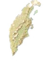
What is so special about the Kamchatka Peninsula in Russia? It is the one of most eastern parts of that country, but in geological terms, it is where different parts of the earth literally come together. The 1,250-kilometer peninsula lies about 700 miles north-northeast from the Japanese island of Hokkaido; between the Pacific Ocean to the east and the Sea of Okhotsk to the west. Immediately offshore along the Pacific coast runs the Kuril-Kamchatka Trench which plunges 10 kilometers below the surface of the sea. The Kamchatka River and the surrounding Central Valley are surrounded by large volcanic belts, containing around 160 volcanoes, 29 of them still active. This gives the peninsula perhaps the highest density of volcanoes and associated volcanic phenomena in the world. Nineteen of the active volcanoes here are included on the UNESCO World Heritage List. The area is volatile politically as well. After the second world war, the peninsula was declared a military zone, and until the 1990s was carefully guarded by the Russian army. It is only in the past few years that scientists have been allowed in to study. Kamchatka is where three tectonic plates meet (the Eurasia plate, the North America Plate and the Pacific Plate). For many years geologists believed that the peninsula sits on the same tectonic plate as the mainland United States, Canada and Mexico. But this seems unlikely, following recent research by Jody Bourgeois, a University of Washington Earth and Space Sciences professor and her colleagues including Kevin Pedoja of the China Academy of Sciences, Tatiana Pinegina of the Institute of Volcanology and Seismology in Russia. This team suggests that Kamchatka is actually on a separate small tectonic plate wedged between the other three. Their results come from studies of prehistoric earthquakes and tsunamis and have been further confirmed by a more recent earthquake in this region (in 1969) which reached 7.7 on the Richter scale. There were also two earthquakes in 2007. That of 21 April reached 7.7 in magnitude and the lesser one on the 29th of April, a by no means insignificant 6.6 magnitude. The latter quakes were not widely reported because they caused minimimal damage. From the geological view point they were significant. Earthquakes are caused by parts of tectonic plates getting stuck against each other as they drift on the magma mantle of the planet. The strain becomes so great that rocks give way by breaking and sliding along the fault line where the plates meet, releasing their pent-up energy as an earthquake. The researchers particularly focused on the coastal terrain on the northern part of the peninsula, an area that thesemassive tectonic events have pushed up and tilted. Their research shows that Kamchatka sits atop a small plate called the Okhotsk block. This block in in sort of convergence zone of tectonic plates, and is getting squeezed from all sides. Pressure from the three surrounding much larger plates has probably caused the raised and tilted land along the Kamchatka coast. Although evidence of prehistoric tsunamis was most important in shedding light on the processes at work on Kamchatka, (by showing how the waves had flowed) the 1969 earthquake and the that of April 21 allowed the scientists to calibrate their measurements and understand just how much the terrain is being squeezed. |
| _______________________________ | ||||
| Home | | | Shopping | | | Database |
© Biscuit Software 2004-2015
All rights reserved